
Training Systems
uas procedural trainer
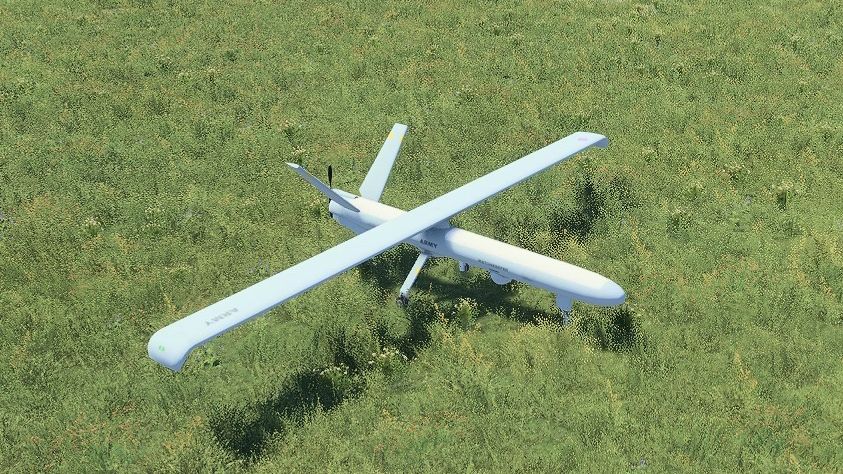
UAS Procedural Trainer
Complete procedural training for unmanned aircraft crews
UAS Procedural Trainer is a free-standing simulation system developed for training crews operating fixed-wing, MALE-class unmanned aircraft systems.
The platform reproduces the complete mission cycle, including taxiing, take-off, en-route flight, sensor operation, target management, precision engagement, return-to-base procedures, approach and landing.
The system is delivered as an integrated three-station training solution comprising:
- a UAS pilot station,
- a sensor and weapon operator station,
- an instructor station.
The pilot and sensor operator stations are installed next to each other to support realistic crew coordination. Communication between both operators and the instructor is provided through dedicated headsets with integrated microphones.
Built on VBS4, the trainer combines aircraft control, mission-system operation, instructor supervision and after-action review within a single operational environment.
Simulated aircraft platform
The simulated aircraft represents a fixed-wing unmanned platform with a wingspan of at least 10 metres.
Its configuration includes:
- two external weapon suspension points,
- a retractable tricycle landing gear system,
- a steerable nose landing gear,
- a turbofan, turboprop or piston-engine propulsion model,
- two independent communication systems.
The landing gear can be retracted after take-off and extended before landing. The steerable nose wheel enables controlled taxiing and ground manoeuvring within the airfield area.
The aircraft performs conventional runway take-offs and landings and can operate at a simulated altitude of at least 30,000 ft AMSL. Its maximum simulated airspeed is no lower than 150 kts.
During take-off, speed increases continuously from 0 kts to the rotation range of approximately 80 kts ±15 kts. After touchdown, the aircraft decelerates progressively from the landing speed range until it comes to a complete stop.
Acceleration and deceleration depend on the current throttle position and the level of braking applied by the operator.
Pilot station
The pilot station is equipped with two monitors, each with a diagonal size of at least 22 inches, installed vertically one above the other.
The upper display presents:
- primary flight parameters,
- aircraft-system status,
- subsystem condition and alerts,
- information required for monitoring the technical state of the simulated UAS.
The lower display is used for flight-control tasks and includes:
- aircraft position on a digital map,
- platform-control functions,
- an artificial horizon,
- roll and pitch indications,
- airspeed data,
- aircraft heading and flight-direction information.
The station also includes:
- a centrally positioned keyboard and mouse,
- a right-hand joystick for manual aircraft control,
- a left-hand throttle controller,
- a brake-control slider or equivalent proportional input device.
Dedicated hardware switches provide direct access to essential aircraft functions. These controls remain available independently of the main software interface, allowing key actions to be performed if the graphical control layer becomes unavailable.
Flight modes and navigation
The simulator reproduces the ten flight modes defined for the training configuration. The activation logic and aircraft behaviour in each mode follow the operational sequence assigned to that mode.
Training can include:
- manual aircraft control,
- assisted flight,
- automatic flight,
- waypoint navigation,
- approach procedures,
- return-to-base operations,
- emergency landing,
- ground taxiing.
Manual flight includes defined roll and pitch limitations to prevent the aircraft from exceeding the permitted operating envelope.
The mission-planning system supports at least:
- 30 independent flight routes,
- 100 waypoints on each route,
- 30 independently programmable return-to-landing routes,
- 30 taxi routes,
- 20 taxi points on each taxi route.
After reaching the final point of a programmed return route, the aircraft automatically transitions into the approach phase.
Sensor and weapon operator station
The sensor and weapon operator station is equipped with two monitors of at least 22 inches each, arranged vertically.
The upper display provides access to:
- advanced sensor settings,
- sensor operating parameters,
- weapon selection and activation,
- aircraft position on the mission map,
- the area currently observed by the sensor,
- marked-target management,
- mission and engagement functions.
The lower display presents:
- live imagery from reconnaissance sensors,
- simplified target-management controls,
- coordinates of the area located at the centre of the sensor image.
The operator station includes a keyboard and mouse for managing advanced sensor, target and weapon functions.
A dedicated right-hand joystick is used to control the observation system. The controller provides:
- sensor pan and tilt control,
- switching between daylight and thermal-imaging channels,
- adjustable optical or digital zoom,
- target-marking functionality.
When the operator marks an observed object, its coordinates are stored and a corresponding marker is displayed on the mission map.
Dedicated hardware switches positioned next to the displays provide direct access to the sensor and weapon functions required by the operational configuration.
Observation and target management
The simulated observation system supports complete reconnaissance and surveillance workflows.
Available capabilities include:
- 360-degree sensor-head rotation,
- vertical sensor movement,
- EO daylight observation,
- IR and FLIR imaging,
- automatic target tracking,
- coordinate generation,
- MGRS geolocation,
- image zoom,
- video recording,
- target marking and cataloguing.
The system allows operators to mark at least 100 separate objects. Stored targets can be renamed, reviewed and associated with their recorded coordinates.
Sensor effectiveness can be affected by environmental conditions such as:
- fog,
- smoke,
- dust,
- limited visibility,
- night-time conditions,
- adverse weather.
Precision engagement training
The trainer supports the complete precision-engagement sequence, from target detection and identification to weapon release and battle damage assessment.
Training functions include:
- weapon selection and activation,
- configurable precision-guided munition profiles,
- semi-active laser-guidance procedures,
- target designation,
- launch or release authorisation,
- engagement-status monitoring,
- circular error probable indication,
- target-database management,
- post-engagement assessment.
The weapon-release mode follows the defined operational workflow and requires the crew to complete the appropriate identification, designation and engagement stages.
The simulated aircraft uses its two weapon suspension points to represent the configured payload options.
Instructor station
The instructor station is equipped with two monitors, each with a diagonal size of 22 inches.
The first monitor is used to manage the virtual training environment, including:
- mission scenarios,
- weather conditions,
- time of day,
- environmental effects,
- aircraft and system failures,
- moving objects,
- tactical events.
The second monitor provides the instructor with a live view of the displays used by the pilot and the sensor and weapon operator.
A keyboard and mouse enable the instructor to operate the simulation and modify available scenario parameters without programming.
Instructor control and emergency scenarios
The instructor can introduce faults and operational complications during an exercise to evaluate crew reactions and decision-making.
Available failures include:
- engine malfunction,
- GPS degradation or loss,
- communication-system failure,
- sensor malfunction,
- aircraft-system faults,
- navigation problems.
The instructor can also dynamically modify:
- weather,
- visibility,
- turbulence,
- icing,
- wind conditions,
- time of day,
- environmental hazards.
The system supports three defined operating modes for conducting and supervising training sessions.
Virtual environment
The simulation environment includes diversified terrain coverage, developed road networks, airfield infrastructure and areas suitable for reconnaissance and mission execution.
Terrain elevation influences radio communication, allowing crews to train in conditions where hills, valleys and other obstacles may reduce or interrupt signal availability.
The instructor can create and control moving objects within the virtual environment, enabling dynamic training scenarios involving vehicles, personnel or other mission-relevant entities.
System performance
The simulator hardware is configured to ensure smooth and uninterrupted operation for at least 24 hours.
The computing components meet or exceed the required performance parameters and support simultaneous operation of:
- the aircraft simulation,
- flight and mission displays,
- reconnaissance sensors,
- weapon systems,
- instructor functions,
- scenario management,
- recording and after-action review.
All indicators, controls and information presented on the individual station displays correspond to the functions assigned to the pilot, sensor and weapon operator, and instructor.
After-action review
Training sessions can be recorded and analysed after completion.
The review environment supports:
- 3D mission replay,
- aircraft-route analysis,
- operator-action review,
- sensor-video playback,
- target and engagement assessment,
- crew decision analysis,
- instructor comments,
- PDF report generation.
This allows instructors to compare crew actions with the required procedures and identify areas requiring additional training.
Interoperability and delivery
UAS Procedural Trainer supports HLA and DIS interoperability, allowing it to operate with compatible air, land and joint simulation systems.
The platform is delivered as an integrated three-station solution and can be configured for the required training infrastructure, operational procedures and aircraft profile.
